|
Management Support System for Biebrza National Park :: Ecological module :: |
||||||||
| ..::: Home :: Contact :: Wersja polska :::.. | ||||||||
|
|
Works carried out within the scope of MSS ecological moduleI. Completing the BNP database with thematic layers related to land-use changes1. Drawing up of a land-use map presenting the state as of the early 1960-ies.The map was drawn up on the basis of interpreting black-and-white aerial photographs taken in 1962 and 1963: 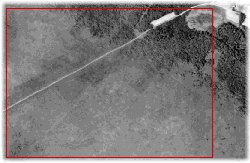
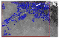 Interpretation of the photographs was performed in relation to geodetic division of the Biebrza Valley. The following elements of land cover structure were distinguished:
The land-cover types listed above were generalised in the land-use map legend. This material shall constitute one of the thematic layers of GIS developed within the scope of MSS. 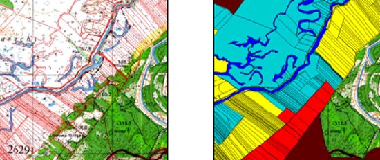
2. Drawing up of a land-use map presenting the state as of the late 1970-ies.Assumptions and cartographic methods in compliance with the above. 3. Drawing up of a land-use map presenting the state as of the late 1990-ies.Works in progress, according to the methods presented above II. Ecological model preparation for the Biebrza Valley1. Ecological modelThe main aim of preparing the ecological model for the Biebrza Valley is the possibility of presenting changes in selected types of vegetation for the adopted scenarios of changes in habitat conditions. The chosen model is the NTM model developed in the Netherlands. It was based on three parameters relevant for the development of habitat conditions, which can be achieved both directly (measurements and field research) and indirectly (modelling results, cartographic studies, phytoindication methods). These parameters are: water availability (F), trophic conditions of the habitat (R) and nitrogen availability (N) which can be estimated on the basis of phytosociological photographs and applying of the so-called Ellenberg scale: 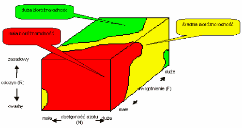 Analysing a sample consisting of an appropriate number of phytosociological photographs, it is possible to estimate the probability of occurrence of a given species/community in a region, in specified habitat conditions. When adapting the model for the Biebrza Valley, two assumptions were made:
Construction of the model includes the following stages:
2. Verification and generalisation of BNP soil map (taking into account the scope of ecological model under construction)The aim of verification and generalisation of BNP soil map under MSS is to prepare reference material, which will be used in ecological modelling (stage of scenario testing). Verification and generalisation of soil map involved both indoor studies and field research. The indoor studies were connected with developing methods of soil map verification and generalisation. Field works were carried out in 150 places situated in all Biebrza basins. The scope of research included determining of the following:
On the basis of field research results, analysis of BNP vegetation map, as well as topographic maps and aerial photographs, the range of particular soil unit demarcations has been verified. Subsequently, the soil map has been generalised for the needs of the ecological model. The developed map shall be a part of GIS. 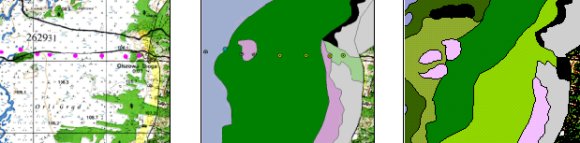
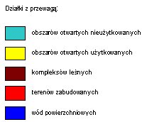
 3. Adapting the BNP vegetation map to the needs of the ecological modelCThe aim of adapting the BNP vegetation map within the scope of MSS is to prepare reference material for the needs of the ecological model (stage of scenario testing). The adaptation of the map consisted in generalisation and adjustment of vegetation map demarcations to the vegetation types specified in the agri-environmental programmes. The following community groups were distinguished:
Out of the above-mentioned plant community groups, the following shall be tested in the ecological model: sedge-moss communities, tall sedge communities, litter meadows, reed, reed mannagrass, herb communities, disturbed meadows and nitrophilic river-bank grasslands. The adaptation of the vegetation map involved both indoor studies and field research. The indoor studies were connected with developing the concept of map generalisation, updating the database, as well as introducing corrections of the range of some demarcations. The field work included verification of some vegetation map sections, taking phytosociological photographs for the purpose of documentation of Biebrza Valley plant communities, as well as collecting biomass samples in order to determine productivity of the communities tested within the model. During the field works 130 phytosociological photographs were taken and productivity of plant communities was estimated for 80 places. 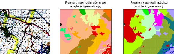 |
|||||||
|
|
||||||||
|
||||||||